Phoenix Weather Report for Dec 1st, 2020
Forecaster: Henz, D
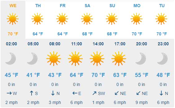
Today’s weather will be sunny with light winds for the Greater Phoenix Metro Area. Temperatures are expected to reach 71 degrees today. Tonight will be clear skies with a low of about 43 degrees. Winds light and variable.
Today marks the start of meteorological winter (Dec-Feb) and we’ve finally been bucking the endless heat trend of 2020.
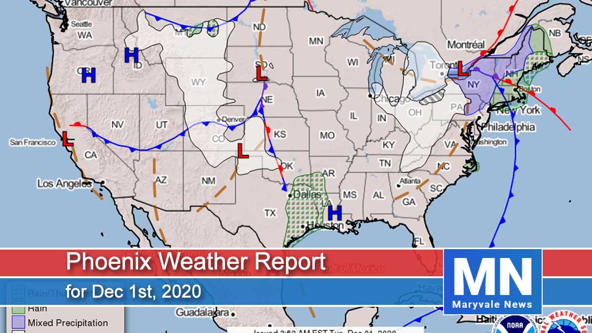
Looking at the big picture, our next disturbance will dig south into the Great Basin/lower Rockies region Wednesday into Thursday, which will likely bring some increased breezes to AZ and lower daily high temperatures into the mid to upper 60s across the lower deserts.
Extended guidance is still coming into better agreement on how long this system will linger over our region, but it’s pretty safe to say the winter season will start off with mild temperatures through at least the end of the week.
For tomorrow plan on another healthy dosing of the sun across the lower deserts. Daytime highs will warm back into the 69˚F-71˚F range around the Valley. Variable winds will generally remain in the light region through the afternoon before increasing east/northeast breezes overnight with gusts in the 15-25mph range.
Heading into Thursday, plan on a drop in temperatures into the mid-60s to go along with continuing breezy/windy conditions throughout the day as the aforementioned disturbance moves into AZ.
 Air Quality Forecast
ADEQ Meteorologist: M. Pace
It’s chilly this morning in Phoenix, appropriate for the first day of December. But low temperatures stopped in the upper 40s, which is about normal for this time of year. In general, this week will be a relatively cool one with highs in the 60s and lows in the 40s. We may have one more day of highs in the low 70s today, though.
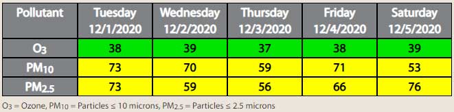
Unfortunately, as mornings continue to get colder, the potential for elevated PM10 (i.e. dust) and PM2.5 (i.e. smoke) levels will grow. This is because of the “inversion,” which is a layer of warm air just above the ground that acts as a lid to trap particulate matter (PM) near the ground. Learn more about the inversion HERE.
Overall, both PM10 and PM2.5 are forecast in the Moderate Air Quality Index (AQI) category each day this week. Cooler temperatures and light winds in the morning and overnight hours will be favorable for the local build-up of PM. The main exception will be Wednesday night into Thursday however when winds are forecast to be breezy and out of the northeast. These winds are expected to help limit PM build-up, though we can’t rule out the possibility of pockets of dust.