Phoenix Weather Report for Nov 25th, 2020
Forecaster: Waters, S.
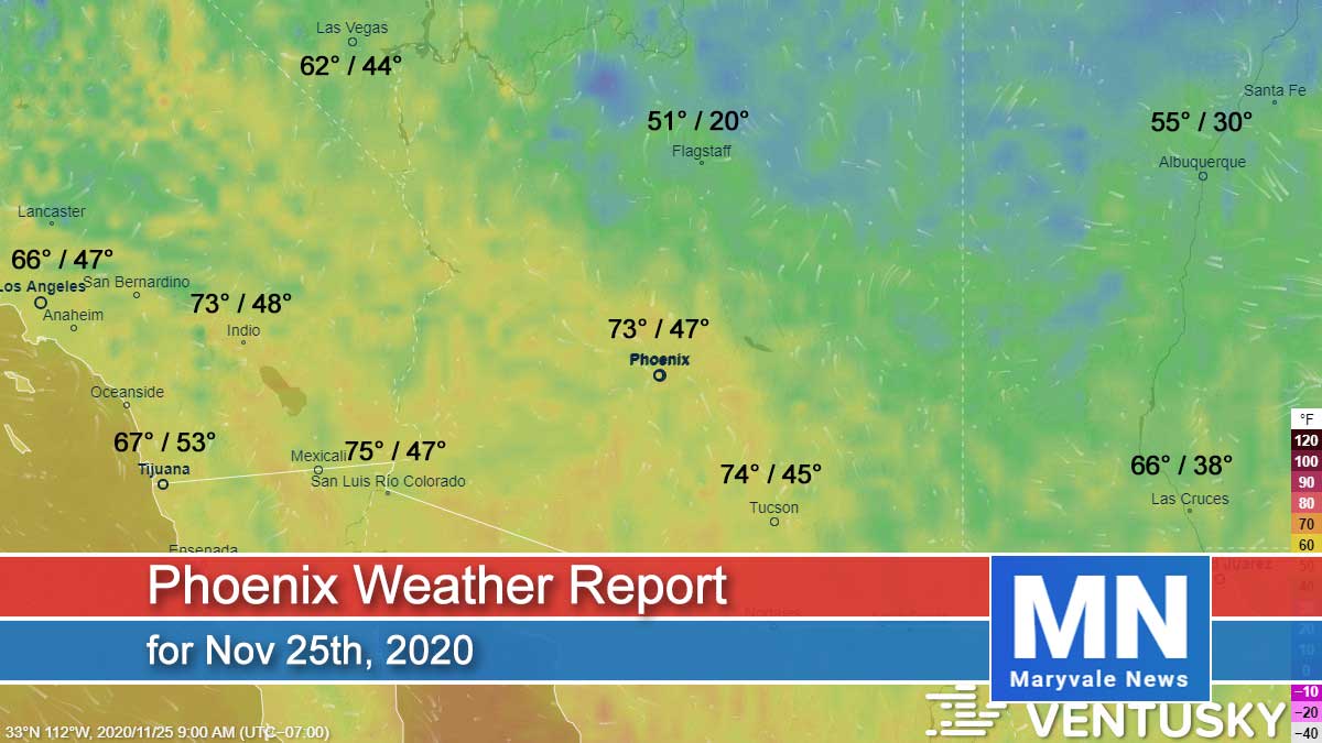
Today’s weather will be sunny with light winds, the Greater Phoenix and Gila Bend area is expected to be around 71 degrees.
Tonight will be clear and calm in the middle 40s for Phoenix and in the low 40s for northern Arizona.
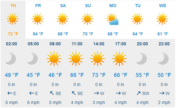
Tomorrow we can expect a few clouds, afternoon breezes and highs around 73 most of Arizona with an overnight low of 48.
On Friday we should have a sunny day with ight winds and daytime highs around 64 with overnight lows in the mid 40s.
Saturday we will begin to warm up again with mostly sunny skies, light winds and our daytime highs around 68.
Sunday will continue to warm with mostly sunny skies and light winds and temps reaching 70 degrees.

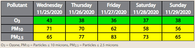
Air Quality Forecast
ADEQ Meteorologist: M. Pace
Water vapor satellite this morning (Wednesday) shows our next storm system moving into the Pacific Northwest. This system will drop southward into Arizona Thanksgiving Day into Friday. Unfortunately, this storm will stay inland as it drops south, meaning it won’t have much moisture with it, so no rain chances in Phoenix. It will help to drop afternoon high temperatures into the upper 60s on Friday.
Breezes are expected to increase just slightly at the surface tomorrow. More importantly, for pollution dispersion, southwest winds will increase into the 10-20mph range above the surface (around 5,000ft), which will help keep PM-2.5 slightly lower than it otherwise would be on a holiday. With that said, with increased fireplace and firepit use likely on Thursday night, coupled with stronger inversions Friday morning, expecting PM-2.5 (smoke) and PM-10 (dust) concentrations to be in the upper Moderate AQI category on Friday, with the highest concentrations during the morning hours.
One other thing we will be watching closely is gusty winds across Western Arizona Thursday and Friday, which will likely produce some areas of blowing dust. Right now, we are not expecting this to transport into Phoenix but would not be surprised to see a bit of haze from dust that will combine with the holiday smoke production to make it look rather hazy Friday morning.
Saturday into the first part of next week, forecasting a ridge of high pressure to build back over the region, which will result in mainly light winds and a warming trend with afternoon high temperatures rising back into the mid-70s by Monday.