Phoenix Weather Report for Nov 18th, 2020
Forecaster: Henz, D.
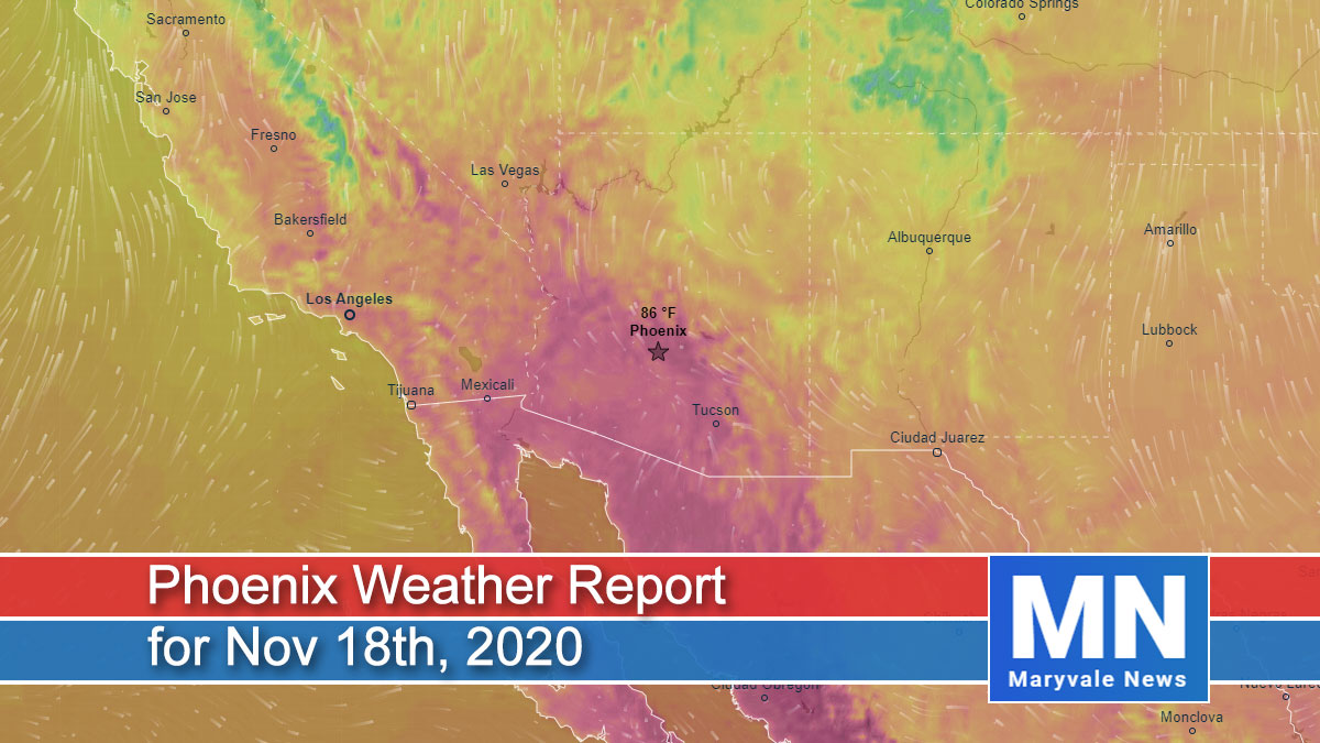
For the second straight day, Sky Harbor reached 92˚F setting another daily high-temperature record and extending the latest 90˚F reading in Phoenix by another day. I’d like to say this string of 90˚F + days is over, but it looks like we’ve got one if not two more days of this.
The good news is the ridge of high pressure that’s promoting this heatwave will move east of the region by Thursday and we should then see a few dry disturbance moves across AZ into early next week. Ultimately, temperatures will trend back towards seasonal normals.
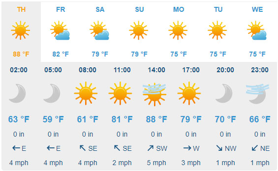
For today plan on mainly sunny skies after some morning high clouds. Afternoon temperatures will climb into the 87˚F-90˚F range around the Valley (Record is 88˚F, set back in 2008). Variable winds will hover in the 2-8mph range with no gusts of any consequence to contend with throughout the day. Overnight lows will dip into the low 60s around the urban corridor with outlying communities reaching the 50s.

For tomorrow plan on clear skies to start the day with increasing high clouds later in the afternoon/evening. Daytime highs will warm into the 87˚F-90˚F range around the Valley (Record is 88˚F, set back in 2007). Variable winds will hover in the light category with no gusts of any consequence.
Heading into Friday, plan on highs stepping back towards the 87˚F mark with periods of overcast skies due to passing high clouds. Additional cooling is expected this upcoming weekend to go along with dry and quiet weather conditions.
Air Quality Forecast
ADEQ Meteorologist: M. Pace
Phoenix did it again yesterday (Tuesday) with a high of 92 degrees. This high broke the record for the day of 87 degrees set in 2008 and broke the record for the latest 90, 91, and 92-degree day, which was set all the way back on (drum roll, please)… Monday.
Water vapor this morning shows a trough across the Pacific Northwest, with high pressure over the middle of the country. This pattern should result in slightly cooler temperatures today, but afternoon highs across the Valley of the Sun are once again forecast to be in the upper 80s to low 90s. Likely another record-setting day as the record high for today is 88 degrees.
Temperatures will remain in the upper 80s through Friday as, for the most part, the pattern remains unchanged. Saturday through the first part of next week, several weak disturbances will brush through the state, helping lower temperatures back into the 70s by Sunday into the first part of next week.
For the Valley, winds are forecast to remain light through the forecast period with no rain in sight.
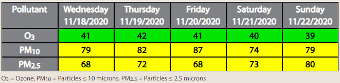
As for air quality, we continue to remain very focused on PM-10 and PM-2.5 concentrations, as several factors are resulting in high levels of PM during the early morning and overnight hours. (1) With how dry it has been lately, dust can easily be picked up and suspended in the atmosphere. (2) Stronger morning and overnight inversions trap dust and smoke close to the surface, increasing concentrations. (3) Very light winds are allowing for dust and smoke to collect over multiple days in the Valley. (4) With cooler temperatures and as we approach the holiday season, more residential fireplaces are being used, which, combined with the other factors noted above, leads to a further increase in pollution levels.
As a result, PM-10 and PM-2.5 are forecast to be in the upper Moderate AQI category through the forecast period. Right now, we do not have any High Pollution Watches or Advisories in place, but we will be watching trends very closely, especially since these stagnant conditions are forecast to continue into next week.